When we hear of hiking and outdoors in the United States, we tend to associate it with Yosemite. Or the Grand Canyons. In any case, it will definitely be a national park in the west coast. What about the east coast? I mean they say east coast best coast right?
We’ve lived and worked in New York City for a couple of years. While the city is great, sometimes we just need a little outdoor break. We are here to uncover some amazing hiking gems that exists around the east coast region.
Here is a list of some of the top hiking trails we’ve been on near New York City that we think everyone in the area should attempt!
Breakneck Ridge Trail

Time needed: 3 hours
Time from city: 1.5 hours
Difficult: 2/5
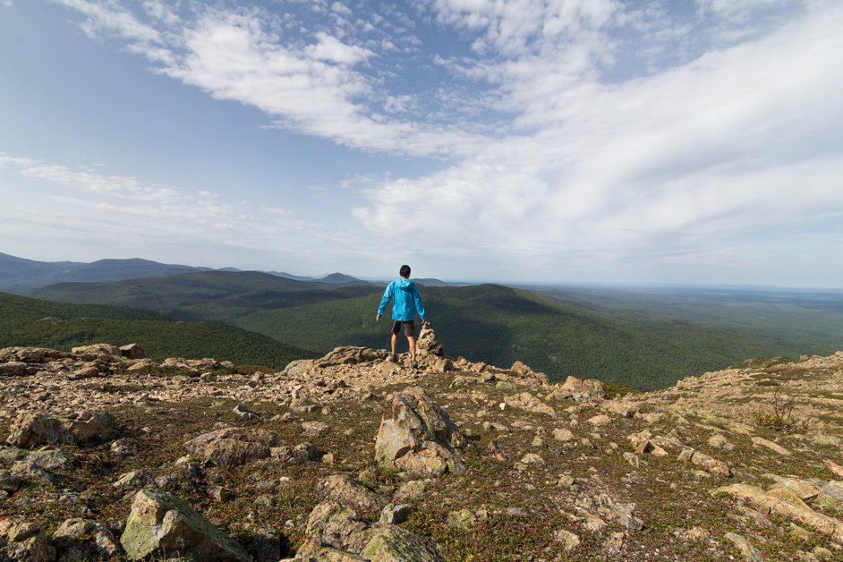
The breakneck ridge trail is one of the most popular hiking route near New York City. It is located just 1.5 hours away from downtown New York.
By hiking to the top, it will grant you a panoramic view of the Hudson River. It is also a quick get in get out trail, which means you can easily complete it in a couple of hours. Its easy accessibility from the city makes this a very popular trail for New Yorkers to satisfy their hiking needs during the weekends.

Although many resources online claims that this is a scrambling trail, we don’t really think so. There’s only a very minimal amount of scrambling required when you’re on the rock faces. Most of the trail involves walking in the dense forest.

How to get to Breakneck Ridge trail from New York City
Car
The easiest and most convenient way is to get there by private car. According to Google maps, the journey will take your 1 hours and 15 minutes.
You can conveniently park your car along the road at the trail head. However, during the weekends it might get very crowded and you might have to park it a distance away from the actual trailhead.
Train
This is a very convenient method and the one we used to get to the trail head.
If you’re travelling during the weekends, head to Grand Central Station and purchase tickets to the Breakneck Ridge Station. You’ll be taking Metro North Railroad’s Hudson Line.
As you can see from the picture above, the station is very small and easily missable. Be absolutely attentive when you’re on the train to make sure you catch the stop!
Click here for the latest MTA schedule.
If you’re travelling during the weekdays or when Breakneck Ridge station is closed, you will have to drop off at nearby Cold Springs Station. From Cold Springs Station, it is a 3.2km (2 miles) straight walk to the trail head.
Bonticou Craig Trail

Time needed: 2 hours
Time from city: 1.5 hours
Difficult: 3/5
Further upstate in the Mohonk Preserve lies the Bonticou Crag Trail. We highly recommend this trail for anyone who really likes scrambling.
You’ll have to literally get on all fours to climb up the rocks. Alternatively, you can make a detour around the rocks but that will take you an additional hour. And you’ll miss out on the fun!

From the top of the trail, you’ll get an incredible view of the upstate plains. If you come during the evening hours and your eyes will be treated to an incredible golden hour sunset.

How to get to Bonticou Crag trail from New York City
Car
Driving is only reasonable way we’ll recommend anyone heading to Bonticou Crag trail. The trailhead is not easily accessible and public transportation to nearby stations are expensive.
From New York City, you’ll need to take a 143 km (88 miles) drive upstate to the trail. It should take you 1.5 hours driving on the I-87N highway.
Do take note that there’s a $15 per person entrance fee to hike in the preserve.
North Point Summit, Storm King State Park

Time needed: 2 hours
Time from city: 1 hour
Difficult: 1/5
The North Point Summit trail is another trail located beside the Hudson River. This is an easy trail that’s very suitable for anyone looking for a quick escape from the city.
The trail head is not very obvious from the main road, so some searching will be needed.
At the top, you’ll be greeted with a refreshing view of the Hudson River!
READ ALSO: 6 things you must do when visiting Vermont, USA

The markings on the trail is not very obvious. Therefore, be sure to download an offline map on your phone to make sure you don’t get lost!
How to get to North Point Summit trail from New York City
Car
To get to the trail head, using car is probably the best option.
From New York City, it will be a 95 km (59 miles) drive to the trail along the Palisades Interstate Parkway.
Bus
You can choose to take a coach service which departs Port Authority Bus Terminal towards Storm King Art Center. The bus journey will take 1 hour 25 minutes.
From the Art Center, grab an Uber or Lyft for a 15 minutes car ride towards the trail starting point.
Mount Katahdin and Hamlin Peak Loop, Maine
Time needed: 12 hours
Time from city: 9 hours
Difficult: 4/5
Now we will be venturing out of New York state and further up north to the state of Maine. Mount Katahdin is the highest mountain in the state of Maine and is located within the Baxter State Park.
This is typically the end point for the famous Appalachian Trail.

While you’re here, it’s incredibly remote and far from civilisation. At this point, you’re closer to Canada than you are to New York City.
However, this is also the best place to be if you want to be one with nature and really experience the vast North East mountains.

The entire trail itself is 17.5km long and you will traverse around the mountain. It will take an entire day to do this so be sure to cater enough time for it. We’d also recommend wearing proper hiking shoes as there will be sections where you’ll have to walk on rocks.
The trail is very sparsely trafficked and we didn’t see many people when we were there. Within the park, we seldom had cell signal. The State Park is Maine’s largest wilderness and is intentionally preserved as such. There will also not be any potable water, stores or even electricity when you’re in the park.

How to get to Mount Katahdin and Hamlin Peak Loop trail from New York City
This is where the definition of “near” gets stretched a little.
Car
You first have to get from New York City to Baxter State Park. This by itself is going to be a long drive. From New York City, you can drive 864 km (537 miles) into the park and subsequently the trail head.
Alternatively, we’d recommend taking coach / Amtrak / plane to Portland, Maine. From Portland, rent a car and drive up 363 km (225 miles) into the park. This will take about 4 hours.
Final Thoughts
There is a common misconception that the east coast does not have any good outdoor hiking trails. We strongly disagree! You do not have to travel far away to experience the outdoors if you’re from New York City.
While the landscape might not be as dramatic and grand as what you’ll get in the west, the trails in the east are typically more remote, more green and on gentler slopes.
We hope that this short introduction to the available trails in the area will spark an interest for more people to explore the north east nature.
Are you looking for even more hiking spots? There are plenty more that we’ve covered before! An example will be the Camel’s Hump trail, located in Vermont state.
Check out our blog post here on what things to do when you’re exploring the beautiful green state!